Slantrange system (continued)
Previous material was dedicated to the hardware part of the Slantrange spectral measuring complex, where the very solid, but not extraordinary capabilities of this equipment were described. Nevertheless, this system deserves a separate description.
Classification of equipment: solutions and purpose
Although the authors have not encountered classifications of such equipment by generations, taken for example, in mobile communication, they are convinced that the Slantrange complex is a representative of a new generation. We will try to offer our classification of spectral systems for UAVs:
- 1G – Clones of satellite solutions, whenUAVs simply mount cameras. The creation of indicator maps, namely the positioning of areas with different vegetation conditions, is carried out remotely in the office;
- 2G – solutions specifically aimed at UAVs, when a special anti-aircraft light sensor is used to obtain reproducible data in real conditions of unstable lighting. Creation of maps of vegetation indices (hereafter VI) as in 1G also primarily remotely in the office;
- 3G – solutions adapted for crop management when, in addition to direct creation of distribution maps of VI, interpretation of results directly in the field is also possible.
Actually, the first and second generations are solutions rather for traders - information about real crop prospects is the basis for pricing policy. For crop management, they are practically not acceptable for a number of reasons, from organizational to purely technical. In practice, agriculturists could receive ready-made data, allowing to judge the potential harvest, on average, a week after flying over the fields. At the same time, the use of more powerful servers or high-speed communication channels to speed up the process of processing images and obtaining ready-made information did not fundamentally improve the situation. Methodologically, at the initial stage, maps were created, according to which characteristic locations were chosen, where then, directly in the field, samples were taken for laboratory research. In addition to the fact that it is difficult and time-consuming, the weekly duration of monitoring is often simply unacceptable - the plants will simply outgrow the necessary stage of vegetation and the correction will be too late. And with selectivity and accuracy at the initial stages of vegetation, which are actually suitable for crop management technologies, there were a number of questions.
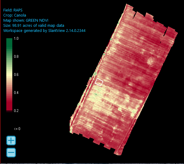
We will demonstrate, as an example, the results of winter rapeseed field monitoring carried out at the end of September 2019. The field had several plots of rapeseed with different predecessor crops (wheat and potatoes).

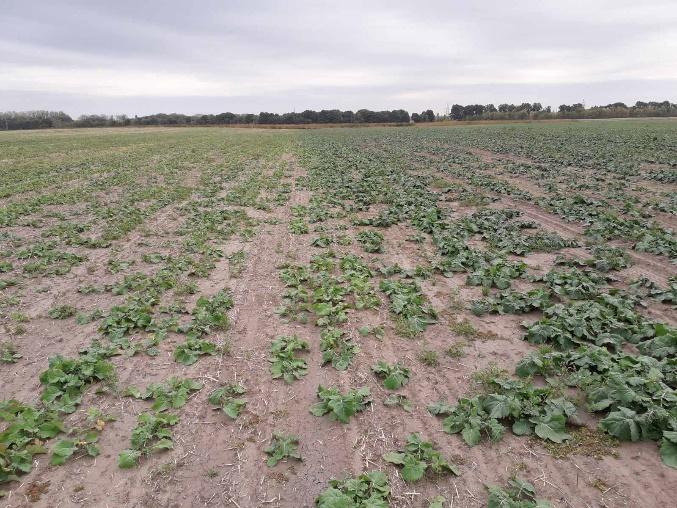
Based directly on the distribution map, we observe: semi-viable (NDVI 0.55 ... 0.65) and practically non-viable (NDVI 0.3 ... 0.4) plants. And in the photograph of the field, the borders of the stress areas (marked with a white rectangle on the map of YOU) we can see plants that are different, but quite alive.

"Live" photo of this field
As a result, the use of ground equipment such as GreenSeeker (described in the article"Ground equipment for monitoring crops by color for the organization of differentiated fertilizer application") other results will be obtained, which of course are not liked by producers.
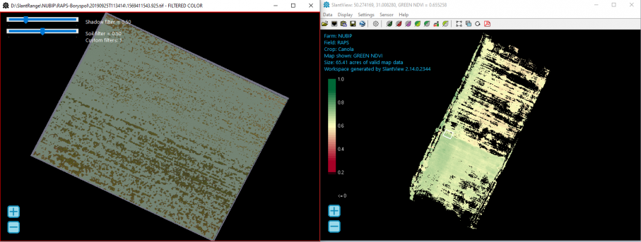
In order to obtain reproducible results, it is necessary to filter the soil. Satellite solutions based on the concept of "ground line" are not effective here. Good results are given by pixel-by-pixel filtering, which is implemented in the Slantview software created during the implementation of the Slantrange system. So, we apply the soil filtration settings recommended by the manufacturer and get shadows: quite a lot of functionality - weed monitoring, counting the number of plants, etc. In practice, in farms that have implemented these technologies, agronomists, on the basis of the distribution maps, can correct the assignment maps for ground equipment, thus rationally use fertilizers, protective equipment and obtain other opportunities and advantages for using them in their technological processes.

Получаем сильно отличающиеся от предыдущей карты результаты – растения есть, данные вполне сопоставимые с наземными исследованиями.
Кроме фильтрации почвы программа Slantview имеет достаточно много функционала – мониторинг бурьянов, подсчет количества растений и другое. На практике, в хозяйствах внедривших данные технологии, агрономы, исходя из карт распределения ВИ, могут корректировать карты-задания для наземного оборудования, тем самым рационально использовать удобрения, средства защиты и получать иные возможности и преимущества для использования их в своих технологических процессах.
Monitoring of stress factors for plants
The authors were not directly engaged in production, and nevertheless, the choice of this spectral equipment was conscious. In 2016-2017, we developed a grain monitoring system for the rational use of fertilizers. Specialized indexes were created to determine the level of nitrogen nutrition, which were positively perceived not only by producers. According to the results of the exhibition, the work was submitted directly to the minister. If a farmer sees only his field, or, at most, also the neighbor's field, the ministry can assess the situation in the entire industry. There, the idea was voiced that fertilizers are all good, but the question of the effect of herbicides is the question that needs to be studied and resolved now.
Unfortunately, the legacy of the disastrous 90s can be felt not only in industry. The ice skating rink passed through the agricultural economy no less. If the factories were cutting metal, then in the agricultural economy, in many places, a "temporary" came, who managed his economy completely thoughtlessly, according to the scheme "after me, at least the flood." The motto "Maximum profit here and now" led to the fact that the number of cattle was drastically reduced, mainly corn, sunflower, rapeseed and, as a holiday, wheat were cultivated.
As a result, new stress factors for plants have appeared, which unfortunately have their own national specifics - we called them stresses of a technological nature. All this, and the described effect of herbicides, when the remains of herbicides from last year's harvest suppress new crops, as well as the thickening of crops and other stresses, are consequences caused by non-compliance with production technology.
Here are exactly the solutions from Slantrange, were out of competition. If there is no one to complain about climatic changes, technological stress has a concrete culprit. Unfortunately, traditionally, in our country with production discipline in plant growing, there were problems, since the fields are huge and, for the owner personally, it is not realistic to bypass them, then the employees could "cast a shadow on the wickerwork" by talking about the machinations of crows, drought and other factors, motivating that "God did not give."
In addition to corruption, the situation was aggravated by the drop in the qualification level of agronomists, and the low prestige of this specialty in the 90s and early 2000s. So we get chemical poisoning of crops with improperly applied or falsified herbicides.
Agrarian owners do not want to lose up to half of the harvest due to corruption and, accordingly, try to correct the situation. So, to combat the effects of herbicides, special tank mixtures are introduced or a special feeding regimen is selected. But it can be effectively implemented only at the initial stages of vegetation, if the cause of stress is identified.
Based on the analysis of the results of experiments in phytotrons, field stationary experiments and production fields, it was determined that the distribution of stress areas has its own character, which is determined precisely cause of stress.

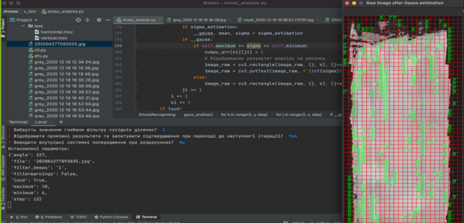
Specialized Python software was created for distribution analysis, suitable both for server solutions and for laptops for work directly in the field.
The question of technological stress is conflicting, therefore, when identifying it is necessary to take samples of plants and soil from such affected areas. This is where the Slantrange complex found its application, the maps from which became the initial data for the analysis. During production tests, received spectral images of a field with an area of 60 hectares were processed in the Slantview program within an hour - distribution maps were obtained, after which, in a few minutes, our program already identified "promising" areas. The agronomists who were present at the field tests of the system were unpleasantly surprised to find that, in addition to the area known to them, left for "experiments", there were also decent areas of damaged plants in the middle of the field. As a result, it turned out that the tractor driver confused something with the high-speed mode and as a result applied significantly more herbicide in one place and, accordingly, "saved" in another.
Итог...
Таким образом, применение систем спектрального мониторинга пригодных для управления урожаем таких как Slantrange, самим фактом своего присутствия в хозяйстве уже могут, как минимум, способствовать повышению производственной дисциплины. Кроме того, анализ развития посевов позволит выявить причины стрессов и разработать эффективные стратегии восстановления плодородия почв. Это нужно, это наша земля и нам тут жить.
Natalia Anatolievna Pasichnyk (n.pasichnyk@nubip.edu.ua)